
The 110 Walkway
You can walk from Lincoln Heights to Elysian Valley alongside the traffic speeding by on The 110 Freeway via a seldom-used pedestrian right-of-way, complete with giant concrete spiral steps, known as the 110 Walkway.
The 110 Freeway
The 110 Freeway, also known as the Historic Arroyo Seco Parkway (and once known as the Pasadena Freeway, back when Los Angeles freeways had names) is the nation’s first freeway. It connects Downtown Los Angeles with Downtown Pasadena, and officially runs from the Four Level Interchange (the juncture of the 110 and the 101) through Pasadena to the corner of Fair Oaks and Glenarm.
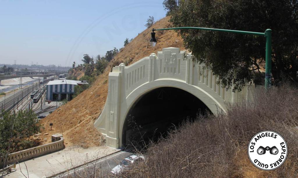
It was built starting in the early 1930s, when the four Art Deco tunnels were blasted out of the hills to extend Figueora Street. For much of its length, it follows the route of the Arroyo Seco (Spanish for dry creekbed) from the base of the San Gabriel mountains toward Downtown Los Angeles and its confluence with the Los Angeles River.

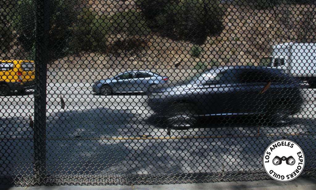
The freeway was designed for maximum speeds of 45 miles per hour, but — although the design hasn’t changed much in 80 years — today it carries a speed limit of 55. Most drivers exceed that, a fact that can make driving it dangerous, especially exiting and entering at one of the parkway’s ridiculously short on- and off-ramps. If you’ve ever tried to exit at Avenue 60 or enter from Avenue 43, you know it can be a white-knuckle experience.
Although the road has seen some minor safety upgrades over the years (adding a concrete median divider, for example), for the most part, it remains much as it was the day it opened in 1941.
The Mysterious 110 Walkway
For some reason, part of the original design included a mile-long walkway that allowed for pedestrians to traverse its length in the manner of walking along a city sidewalk. I’m not sure what the intent of this was, other than to allow people to walk from Lincoln Heights to Elysian Park. You can see evidence of this walkway in early photographs of the freeway.
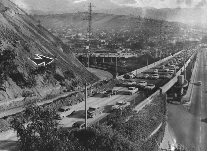
The walkway — and some of the Arroyo Seco Parkway proper — was supposedly built by the Works Progress Administration (W.P.A.), President Franklin Delano Roosevelt’s program to get Americans back to work in the wake of the Great Depression. Many W.P.A. projects weren’t exactly essential, so perhaps the 110 Walkway was one such project.
The 110 Walkway spans about one mile from Stadium Way at the east end of Chinatown to North San Fernando Road at the juncture between Lincoln Heights and Cypress Park.
Walking The 110 in L.A.
This walk is described beginning at the eastern entrance off North San Fernando Road and walking west to the walkway’s terminus at Stadium Way in Elysian Park.
Important note: If you’re driving here, you can’t park along North San Fernando Road (nor would you really want to). The best spot to park is at the nearby Confluence Park, which shares a corner of the Home Depot parking lot. On the way over to the beginning of the 110 Walkway, you’ll pass Faces of Elysian Valley, an interesting piece of public art.
Another Exploration Nearby …
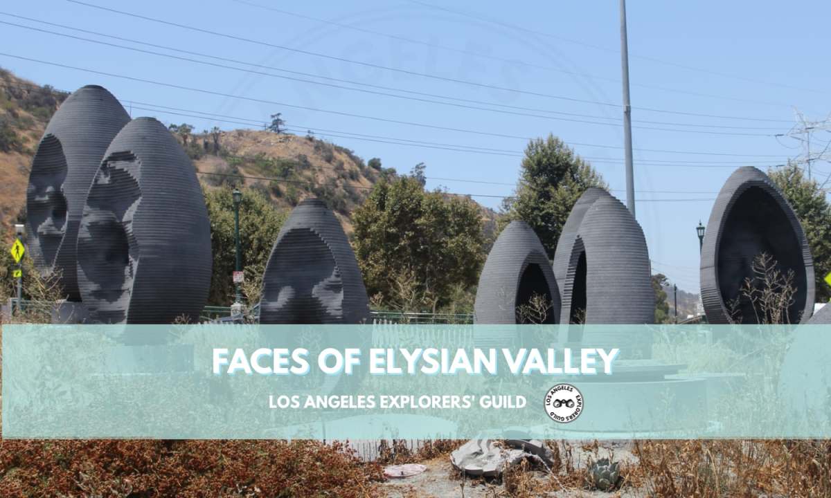
Faces of Elysian Valley (The Riverside Roundabout)
A series of nine egg-like sculptures featuring random faces of area residents keeps vigil over the first true roundabout in Los Angeles.
Keep readingThe First Step is Messy
The first step in traversing the 110 Walkway is climbing up a set of steps that form part of a concrete support for the overpass above. The stairs are sort of hidden, but you can find them at these coordinates: 34.080900, -118.225328.
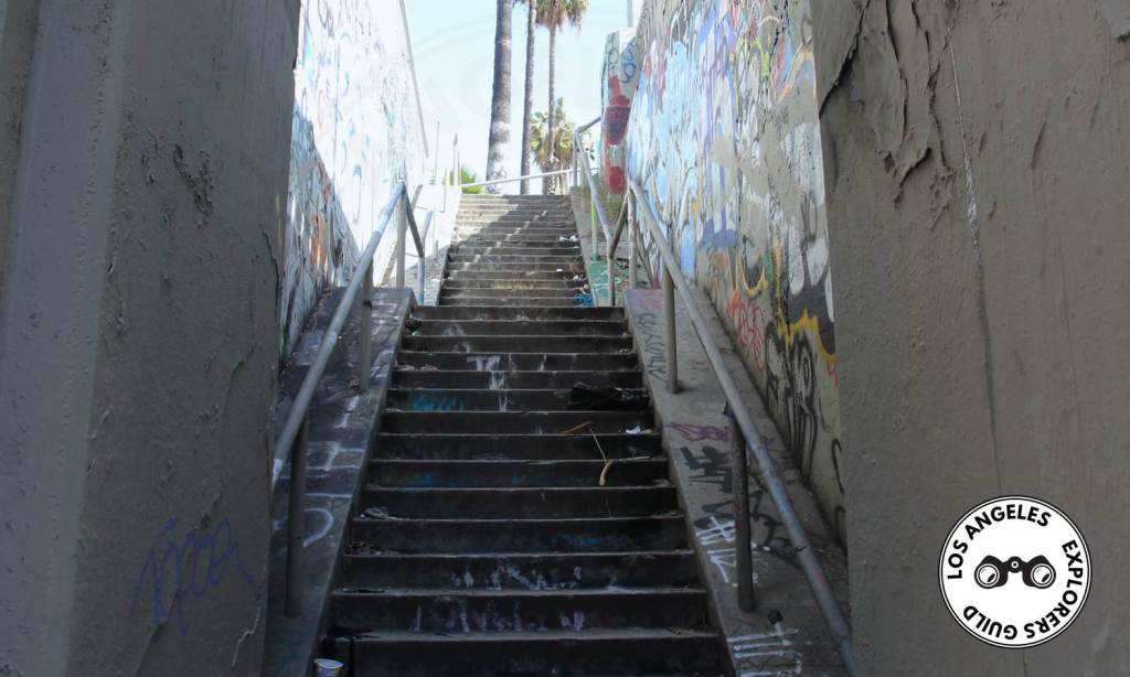
I’m not sure how often it’s cleaned out (if at all), so you’ll probably see all sorts of urban detritus — food wrappers, clothing, shopping carts, empty bottles, spent needles — strewn about.
From this stairway, you’ll walk along the 110 South for slightly less than half a mile, facing the cars driving into Pasadena, until you reach the rather large spiral steps. At the bottom of the concrete corkscrew steps, you can stand right where the 5 North splits off from the 110 north, distressingly close to the oncoming cars. There are safety barriers between you and the oncoming traffic, but I’m not sure they’d be all that effective if a car decided to plow into the staircase.
Road, Rail, River
This spot is also the city’s ultimate confluence — where road, rail, and river meet. The 5 splits off from the 100, the 110 crosses over the train tracks from Union Station, the Metro L Line passes by just to the south, and it’s where the Arroyo Seco joins the Los Angeles River.
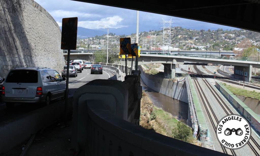
At the top of the spiral staircase, which seems rather wide for a lesser-used pedestrian walkway, you’ll begin walking along the 110 South in the same direction (west) as the cars heading into Downtown Los Angeles. Again, you’ll very close to the traffic here. I’m sure drivers will be wondering what the heck you’re doing standing there, photographing them.
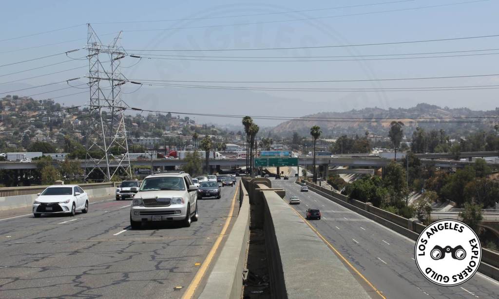
From this vantage point, you’ll have a great view of the old Lincoln Heights Jail (Los Angeles Historic-Cultural Monument 587, if you’re counting). You may recognize it from its roles in American History X, Colors, L.A. Confidential (both the book and the movie), Nightmare on Elm Street, Iron Man 2, and countless television shows and music videos.

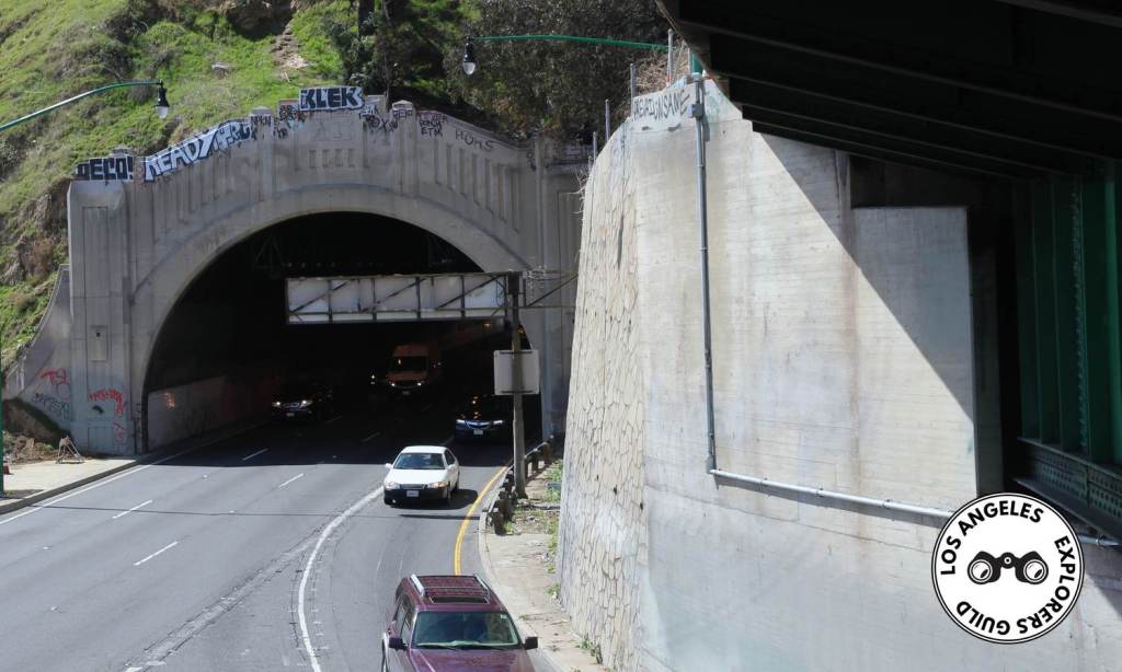
As you walk, the 110 North will be on your left, and you’ll get a great view of the four Art Deco Figueroa Tunnels. The keystone of each tunnel displays the official Seal of Los Angeles.
Middle Access Point and Encampments
Just past the mid-point, right before Radio Hill, you’ll come across the Amador Street exit, one of the three means of accessing the 110 Walkway. During this point of the walk, I saw a man step onto the sidewalk from a large hole in the fence. he greeted me with a cheerful, “Good morning,” then he got on a bicycle and pedaled off. He was well dressed, and it looked like he was going off to work.
The open space between the 110 Walkway and the lanes of the 110 North below are home to numerous encampments, both large and small. Much of this homesteading is concentrated around Radio Hill Gardens.
There is series of tent villages sequestered amongst the vegetation growing along the hills. Some of these are quite elaborate. In one instance, I saw a clothing rack filled with white button-front shirts that looked just like a closet in any home.
Leaving the 110 Walkway via Stadium Way
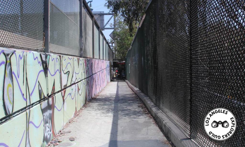
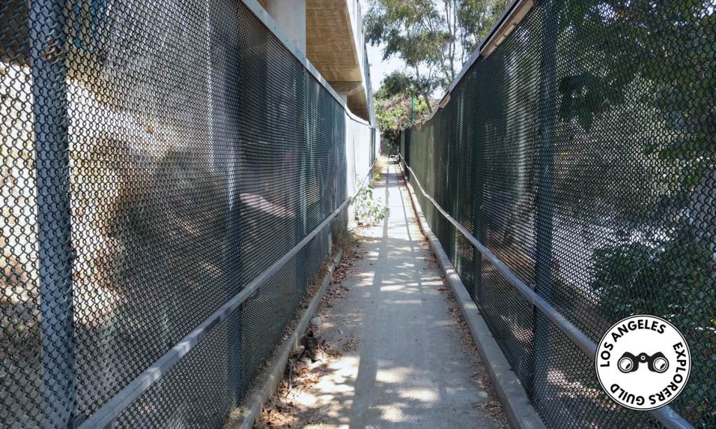
At some point in its history (fairly early on if historic photos are any indicator), the city installed a chain-link fence along the walkways original concrete balustrade. This was a good plan as, again, you are very close to the passing cars. The fence also functions to keep people from tossing trash at passing cars or onto the freeway.
About a quarter-mile after passing the Amador Street access ramp, you’ll pop out of the 110 Walkway on Stadium Way, just a few block north of Broadway and just south of Dodger Stadium.
Of course, now that you’ve made the trip, you have to retrace your steps to get back to your vehicle. Of course you could also find parking in Chinatown, but that’s a whole adventure in itself.
A Walkway to Nowhere?
The intended purpose of 110 Walkway remains a mystery. It doesn’t start or end at anyplace particularly noteworthy. But it’s such a bizarre feature of the city’s fabric, one so uniquely Los Angeles, that if you’re seeking offbeat adventures, this is a great place to explore.
Walking along the freeway can feel dangerous, and not just because you’re so close to traffic. If you find secluded walkways, graffiti, and piles of trash along the sidewalk somewhat uneasy, you may want to just admire this Los Angeles landmark as you drive by.
But if you’re more of the adventurous type, you’ll find the walkway is mostly deserted, and the people you do encounter are just regular folks looking for a place to lay their heads.
The 110 Walkway
- 110 Walkway Entrance East (San Fernando Road) • 34.080900, -118.225328 • ///games.swing.steer
- 110 Walkway Entrance Midpoint (Amador Street) • 34.074872, -118.232595 • ///heap.lanes.trades
- 110 Walkway Entrance West (Stadium Way) • 34.071299, -118.235252 • ///fresh.voted.grit

It’s always looked to me like the eastbound direction roadway (Arroyo Seco Parkway?) was originally for both directions. And, I suspect it had a sidewalk on one side or the other. See also the sidewalk at the face of the last Figueroa tunnel in your picture. I suspect that there was a sidewalk within the tunnel, before they widened the roadway, and before they ultimately constructed the easier-to-build westbound lanes, much higher than the tunnel. I suspect that when they built the westbound new road (perhaps in the 60s?) they also built the sidewalk, to replace one removed from the eastbound road. If the sidewalk were original to the 1940s it wouldn’t have had ramps for pedestrians, it would have had stairs. I suspect those stairs at the far east end may have connected to the original sidewalk, which would have lead into the tunnel. My theory is that the spiral ramp was built in the 60s, to lead up to the sidewalk along the westbound lanes.
LikeLike
Moved here in ’73; but never knew or noticed; probably because i was paying attention to driving that 110 to 5 left! Why didn’t Huell Howser show & tell? lol But glad you did!
LikeLike